Questions? Contact us: info@masondatacenterfacts.org
← Annexation status and public comments

The requested land and its surroundings

Explore the land in detail.

Follow the drain, read the contours and explore the annexation parcels. Choose a map, then use its bookmarks to take a closer look.

Maps prepared by Brandon Baird · Terrain: December 2017 · Parcels: 2026

Interactive map

Topography, drainage and parcels

Loading the topographic map…

Map legend

Topography & parcels

  • Annexation request
  • Request parcel lines
  • Other parcel lines
  • Open county drain
  • Enclosed / tile drain
  • Contours · 1 ft; index 5 ft
  • FEMA Zone A floodplain
  • Mapped NWI wetland

The printed legend remains on the sheet. Choose its bookmark to inspect every symbol.

Keyboard: focus the map, then use arrow keys to pan, +/− to zoom and Home for the whole sheet. Bookmarks open readable detail; drag to explore the rest of a panel.

Reading this view

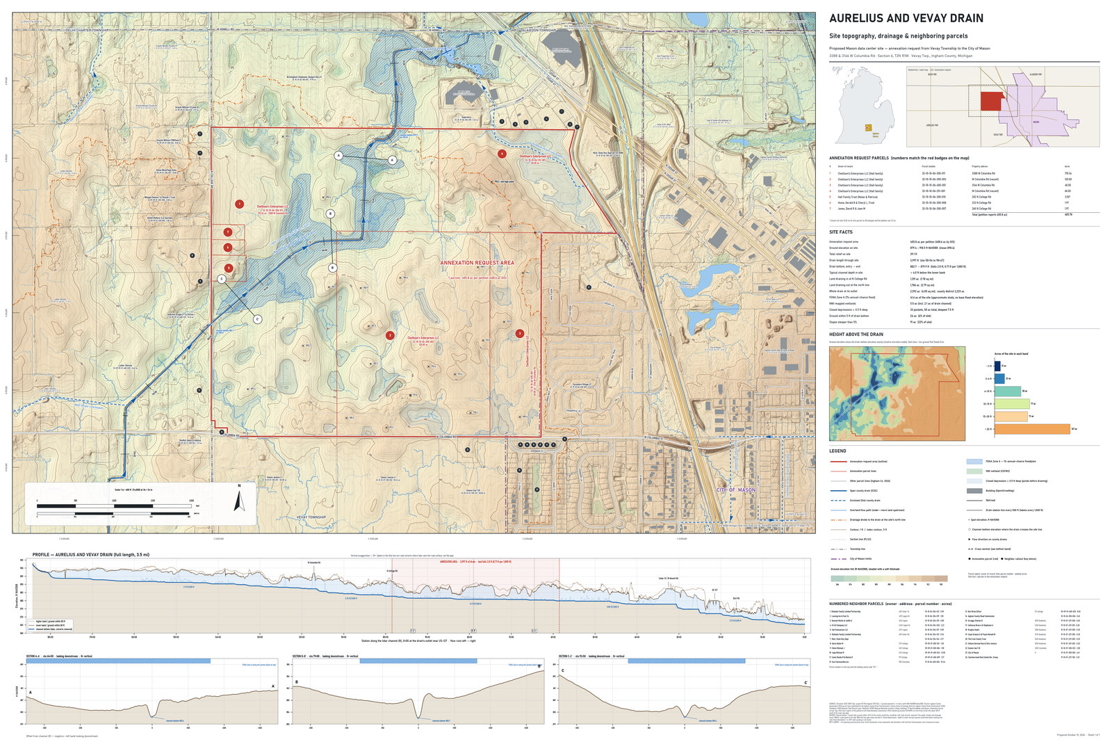
The detailed reference sheet combines contours, open and enclosed drains, the annexation parcels, mapped floodplain and wetlands, a longitudinal profile, and three cross sections.

Contours, profile and cross sections. Read each panel’s labelled axes and scale; the plan view and profiles use different scales.

7,200 × 4,800 pixels

What the colours tell you

The height colours compare terrain with a terrain-derived drain reference. They do not establish a measured water surface, floodwater depth or the effects of a future development. The technical sheet’s FEMA floodplain and mapped wetlands are separately identified in its legend.

The light and dark terrain maps show the same area and information. Switching their appearance keeps your position. The perspective is a fixed image; panning changes which part you see.

About the maps & sources

All four maps prepared by Brandon Baird. The descriptions below explain what each map contains.

Topography, drainage & parcels

The detailed reference sheet brings together labelled contours, parcel boundaries, open and enclosed drains, FEMA floodplain, mapped wetlands and the annexation request. The surrounding panels include site facts, a drain profile, three cross sections, methods and sources.

Prepared by Brandon Baird · 7,200 × 4,800 px

Height above the drain · light

A terrain overview with lower ground in deep teal and higher ground in pale colours. Relief shading, parcel lines, roads and a red request boundary help place the drain in its surroundings. Relief uses 8× vertical exaggeration.

Prepared by Brandon Baird · 10,800 × 7,200 px

Height above the drain · dark

The same area and height information as the light map, with cyan lower ground, darker higher ground and a gold boundary. This alternate palette makes the drain corridor stand out. Relief uses 8× vertical exaggeration.

Prepared by Brandon Baird · 10,800 × 7,200 px

Northeast perspective

A fixed oblique view looking northeast, showing the terrain, gold request boundary, low-ground glow and buildings. The scene uses 4× vertical exaggeration. Use the topographic sheet for precise labels and elevations.

Prepared by Brandon Baird · 6,000 × 4,000 px

The supplied maps cite USGS 3DEP bare-earth lidar flown in December 2017, Ingham County drain information and 2026 parcel data. The detailed sheet was prepared October 15, 2026. Later grading may not be represented. Boundaries, easements, elevations and map-derived estimates should be checked against the original records and appropriate professional surveys or studies.

The technical sheet labels approximately 405.8 acres per petition and 408.6 acres by GIS. It also distinguishes a 2,592-acre terrain-derived watershed from the 2,233-acre official drainage district. These are different measurements, not interchangeable totals.

The web captions clarify the supplied artwork’s references to a “water line” and correct a garbled dash. The mapped outline shows a boundary request, not an approved building layout.

Read the submitted petition and boundary survey · Use the maps when preparing a public comment